


Is a lookout tower tour on your Black Hills itinerary? Here's a list of fire lookouts — some are active, some are open to the public, others are not — how to get there, and what you'll see.
The list includes sites in the South Dakota Black Hills with an extant tower. Former tower sites — Boulder Hill, Castle Peak, Cicero Peak, Crows Nest Peak, Flag Mountain, Norris Peak, Parker Peak, Pilger Mountain, Signal Hill, Terry Peak, Veterans Peak — are not.
Battle Mountain
GPS: 43.44219, -103.45370
Elevation: 4,388 feet
Directions: One block South of Hot Springs' Dew Drop Inn on the 385, turn East onto Thompson Avenue, which becomes Battle Mountain Road. The tower is about 1.5 miles ahead, and the road may be passable for most vehicles in dry conditions.
Info: Though not as dramatic as the Black Elk Peak Lookout, Battle Mountains' is picturesquely situated atop a rocky dome that flaunts an arid, snaky, Southern Hills ambience.
Views: The Seven Sisters Range to the South, Angostura Lake and the sandstone architecture of Hot Springs directly below. The tower itself was locked at the time of visit.
Bear Mountain
GPS: 43.86980, -103.74390
Elevation: 7,166 feet
Directions: Bear Mountain can be approached from a couple directions, accessible via improved gravel roads most cars can handle in summer weather. Bear Mountain Road leads right up to the tower.
Info: The Bear Mountain lookout tower is an actively staffed, all-steel structure. While the tower has been closed to the public, vault toilets and a picnic table are available for visitors. A wood tower (circa 1910's) predated the present steel structure.
Views: In June, Bear Mountain Road is a Rocky Mountain iris lover's paradise. Though the tower may be inaccessible, the heights offer views of the granite core peaks to the East, and limestone plateau to the West.
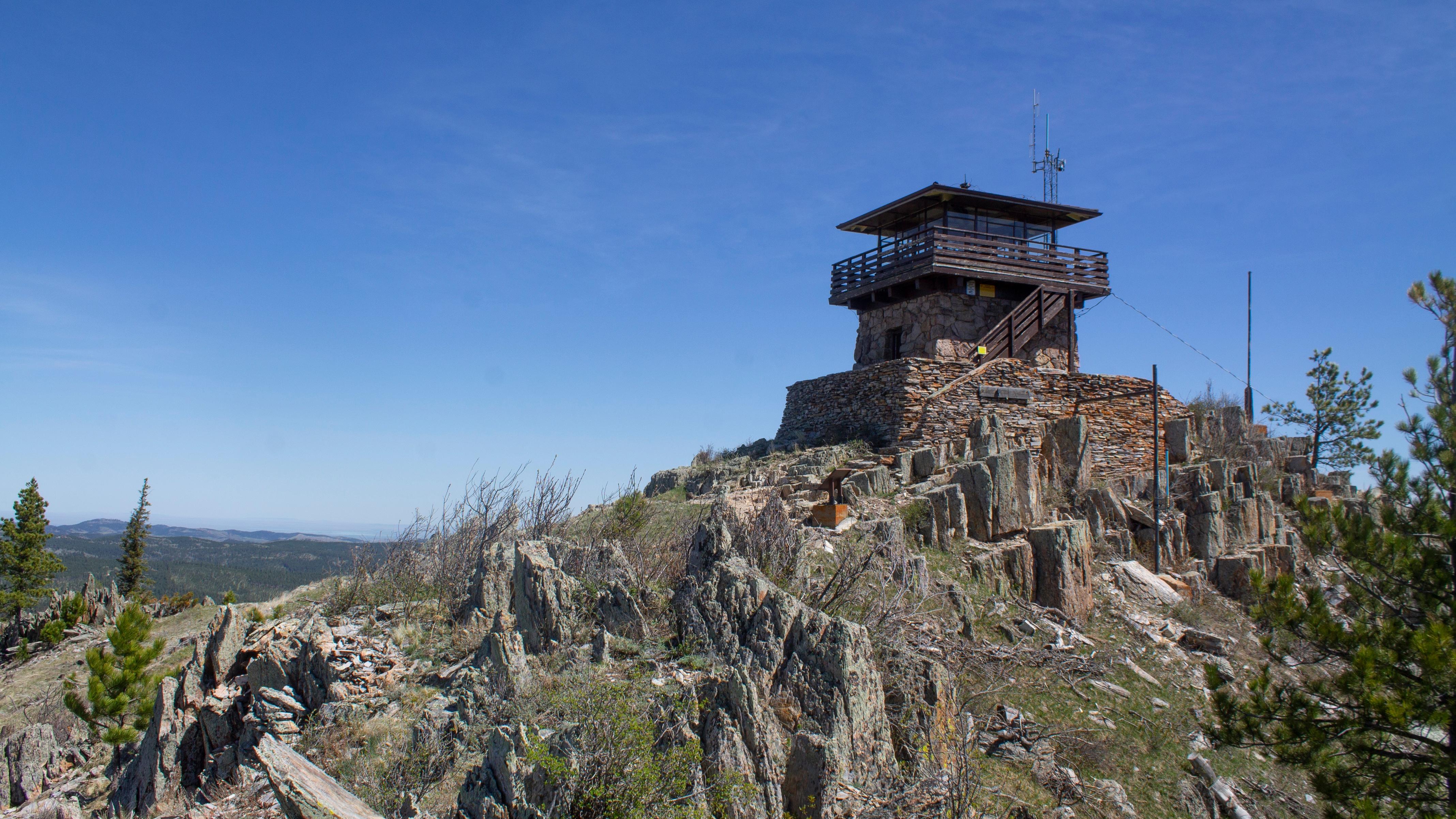
Black Elk Peak
GPS: 43.866100, -103.531100
Elevation: 7,242 feet
Directions: The most popular approach is to park at Sylvan Lake and take one of a couple trails. There's a loop option or an out-and-back, either clocking in around seven miles round trip, and gaining about 1,550 feet in elevation. There are also approaches from the North. The most direct is from Willow Creek campground off the 244. The short Willow Creek loop connects with the Black Elk trail. This route is highly recommended for close-up views of the adjacent Mount Elkhorn, itself a gothic masterpiece.
Info: This is the mainstay of the circuit and requires the most leg work. The effort pays off upon approaching this sacred site, the absolute center of the Hills' lithic iconography.
The tower is an exemplar of CCC stone work, completed in 1938, and open to all. A five-year restoration project was completed in 2018. There is a reservoir, which still fills with rain water, and an inactive pump house. One can wander off away from any summer crowds on large expanses of rock before meeting the true edge. If you're a local with some snow gear, winter views are underrated and easily observed alone.
Views: At America's highest point from here to the Atlantic, you can see for many miles, on clear days all the way to the Laramie range of Wyoming in the West and Badlands in the East. Your correspondent has also seen the peak shrouded in a white fog that centered the gaze hyper-locally, and that was okay too.
Bullock Tower on Scruton Mountain
GPS: 44.04332, -103.52679
Elevation: 5,997 feet
Directions: From Highway 385, turn Northwest on Custer Gulch Road, then continue straight onto Edelweiss Mountain Road. Drive about 1.6 miles total from 385 to the intersection with FS 156, at 44.04294, -103.51889. The gate tends to be closed, but you can walk the approximately 1.8 miles, with an elevation gain of 563 feet.
Info: A wood tower with a small living quarters was built in 1938. That tower was removed and replaced with the present, all-steel tower in 1975. The tower is closed to the public. Bullock fire tower should not be confused with the Mount Roosevelt Friendship Tower, which former Deadwood sheriff Seth Bullock built in tribute to his friend Theodore Roosevelt.
Views: Pactola Lake to the North, to the South peaks of the Black Hills core, including Black Elk. The best views are obtained by climbing a nearby scree pile to the base of an earlier lookout tower, which still has some stone stairs and a small outbuilding.
Custer Peak
GPS: 44.244229, -103.735054
Elevation: 6,804 feet
Directions: From Highway 385, go west on Custer Peak Road about two miles. At a Y intersection, take a right on Forest Service Road 216.2. This road becomes very narrow, steep and rough. Your correspondent parked at a pull-off and walked a little under a mile to the peak. This seems to be a popular area for ATV enthusiasts.
Info: The views are expansive and the location itself is a jagged demonstration of the dramatic, angular uplift that forms the Black Hills' granite core. From here, you can see Bear Butte, Sugarloaf Mountain and many other peaks
Mount Coolidge
GPS: 43.744824, -103.481475
Elevation: 5,971 feet
Directions: From SD 87, follow the sign for the Lookout Tower road. The gate was closed when I arrived, but parks staff plan to have the gate open as of June 20. In the event that the gate is closed, an approximately 1.5 mile walk (445 feet elevation gain) will get you there.
Info: The Civilian Conservation Corps built the extant stone tower in 1939. An active lookout, visitors can access the observation deck, which features postcard views, coin-operated binoculars and a couple interpretive signs about the impacts of the 1988 Galena Fire.
Views: Mount Coolidge offers a refrigerator magnet-like tableau featuring the Black Hills core's major players. To the West, Crazy Horse reaches toward you with an unfinished hand. To the North stands Black Elk peak and the Needles. Further east, presidential forehead gleam glints in your eye.
Elk Mountain
Directions: From HWY 16 take Dewey Road three miles South, take a right on Elk Mountain Road (FS roads 123→818→118), continue to follow signs to the Lookout and stay on the improved gravel road nine miles to the Lookout. Probably passable in an '83 El Camino Super Sport in summer months, when dry (observe conditions).
GPS: 43.72420, -104.04123
Elevation: 5,702 feet
Info: The CCC built the 67-foot steel tower and a log cabin lookout quarters in 1941. The cabin was destroyed by the Elk Mountain Fire in 2001. That, and several other fires, transformed the Elk Mountains into more open country with tons of deadfall, much of which is degraded to mulch at this point. Those changes have helped establish a bighorn sheep herd — which GFP reintroduced the same year as Elk Mountain fire.
Views: To the East, the Elk range fingers out into the wide open Wyoming sage brush prairie. To the South, Wildcat Peak, and a slightly smaller, balder, unnamed peak. To the East, the Southern Black Hills.
Rankin Ridge
GPS: 43.62438, -103.48311
Elevation: 5,013
Directions: From SD 87 in Wind Cave National Park, watch for the sign, then turn East onto a short drive to a parking lot at the trailhead. The hike is roughly one mile round trip, with a little over 200 feet elevation gain.
Info: This all-steel fire lookout was built in 1956, and is occasionally used depending on fire weather conditions. In recent times, your correspondent has found the stairway padlocked.
Views: Ground levels views look out over the billowing emerald hill country of Wind Cave, the sublimity of which is often overlooked for what lies underneath. You may spot a grazing herd of buffalo.
Summit Ridge
GPS: 43.85442, -104.05284
Elevation: 6,116 ft
Directions: The route with the least off-blacktop driving, while avoiding two-tracks, is to take the improved, gravel Boles Canyon Road north from HWY 16 for 11.5 miles, then take a sharp Southwest turn on Summit Road (also an improved, gravel road) another 4.5 miles to the tower. Probably sedan-passable in summer, but condition-dependent. Your correspondent actually got stuck in a snow drift here in March, and had to walk the eleven miles to Newcastle, stay the night, buy a shovel in the morning, and come back to free the vehicle. If this happens to you, I recommend sticking to Forest Service roads, as the red rock canyon walls you must descend feature steep vertical drops.
Info: This is the only fire lookout in the Hills where the public can rent a restored log lookout cabin — in fact, the only cabin rental at all in the Black Hills National Forest. The CCC built both structures in 1942. The cabin is furnished with three bunkbeds (no mattresses), a BYO-propane stove for cooking, wood stove for heat, and separate vault toilet. No wi-fi, electricity, dedicated yoga studio, oyster bar or running water. The 67.5-foot tower was staffed until 1972, and is still occasionally used when fire danger is high.
Views: The tower is closed to the public and at ground-level, any views are obscured by trees. From the road to the mountain, there are views far into the sage brush prairie of the Powder River Basin, and occasionally lesser peaks to the East.